
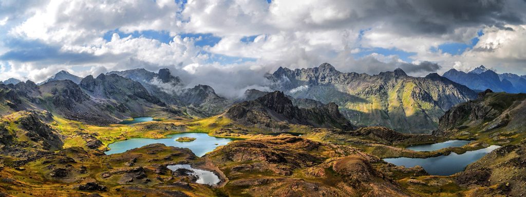
Highest Mountains in Turkey-Top 20
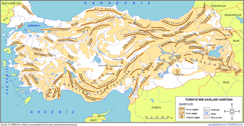
There are 3 types of mountains in Turkey. These are folded, fractured and volcanic mountains according to their formation. What are the mountains of Turkey? The geography of Turkey has a rugged structure. That’s why there are so many mountains.
1) Folded Mountains: These are mountain types that are formed by the bending of the flexible layers due to the compression of the plates. Higher areas are called anticlines, and lower bell-shaped areas are called synclines. For Example : Ilgaz, Canik, Küre, Kaçkar, Çimen, Mescit, Kop, Köroğlu Söğüt, Sultan, Geyik, Karakuş , Dedegöl, Aladağlar, Bolkar, Engizek, Tahtalı, Cilo, Mercan, Munzur, Allahuekber, İspiriz, Mengen ,Elmadağ, Akdağlar, Köse, Demirci, Eğrigöz, Emirdağ.
2) Fractured Mountains: These are mountain types that are formed by the breaking of pressured and hard masses that are too hard to bend. The high places formed by the fracture are called Horst, and the low depression areas are called Graben. For Example: Kazdağı, Madra, Bakırçay, Yuntdağı, Bozdağ, Aydın, Menteşe.
3) Volcanic Mountains: They are formed as a result of the rising and solidification of the hot and fluid magma layer inside the earth from weak sections without resistance. For Example : Ağrı Dağı (Mount Ararat), Tendürek, Süphan, Nemrut, Erciyes, Hasan, Karacadağ and Uludag.
List of mountains by Elevation in Turkey. Which mountains are there in Turkey?
Which are the Highest Mountains in Turkey?
| 1 | Ararat | Ağrı | 5137 |
| 2 | Cilo | Hakkari | 4134 |
| 3 | Suphan | Bitlis | 4058 |
| 4 | Kackar | Rize | 3937 |
| 5 | Erciyes | Kayseri | 3917 |
Which are the 3 biggest mountains of Turkey?
| 1 | Ararat | Ağrı | 5137 |
| 2 | Cilo | Hakkari | 4134 |
| 3 | Suphan | Bitlis | 4058 |
How many mountains in Turkey?
It’s challenging to provide an exact number due to varying definitions and classifications of mountains, but Turkey is home to numerous mountain ranges and peaks spread across its diverse geographic regions. Major mountain ranges include the Taurus Mountains in the south, the Pontic Mountains along the northern coast by the Black Sea, the Eastern Anatolian Mountains with peaks like Mount Ararat and Mount Süphan, the Northern Anatolian Mountains along the Black Sea, and the Central Anatolian Mountains featuring peaks like Mount Erciyes and Mount Hasan. These ranges collectively contribute to Turkey’s rich and varied landscapes, supporting diverse ecosystems and playing significant roles in the country’s geography, culture, and history.
What are the 2 largest mountains in Turkey?
| 1 | Ararat | Ağrı | 5137 |
| 2 | Cilo | Hakkari | 4134 |
What is the name of Turkey’s largest mountain?
List of Mountains in Turkey
| Seq.No | Mount Name | City | Elevation (meters) |
|---|---|---|---|
| 1 | Ararat | Ağrı | 5137 |
| 2 | Cilo | Hakkari | 4134 |
| 3 | Suphan | Bitlis | 4058 |
| 4 | Kackar | Rize | 3937 |
| 5 | Erciyes | Kayseri | 3917 |
| 6 | KüçükAğrı | Ağrı | 3925 |
| 7 | Kizilkaya | Niğde | 3771 |
| 8 | Demirkazık | Niğde | 3756 |
| 9 | Artos | Van | 3550 |
| 10 | Aydos | Konya | 3430 |
| 11 | Medetsiz | Adana | 3723 |
| 12 | Kösedağ | Sivas | 3711 |
| 13 | Hasan | Aksaray | 3268 |
| 14 | Kısır | Kars | 3684 |
| 15 | Palandoken | Erzurum | 3670 |
| 16 | Berit | K.Maraş | 3654 |
| 17 | Nurhak | K.Maraş | 3630 |
| 18 | Sematepe | Niğde | 3623 |
| 19 | Çağalınbaşı | Niğde | 3612 |
| 20 | Tendürek | Agri | 3584 |
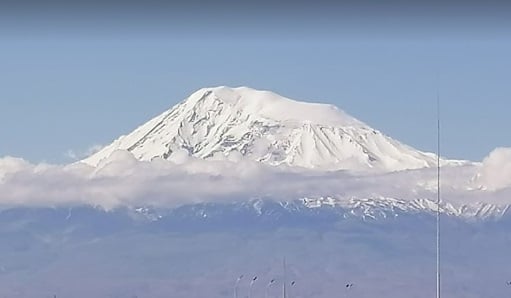
1.Mount Ararat (Agri)
Where is the Mount Ararat ?
Ararat is located in Ağrı city of Turkey. You can see Mount Ararat of Google Maps Please Click.
Ararat Photos of Google Photos
Click for many beautiful Google Photos of Ararat.
More information About Ararat
When we look at the ranking of Turkey’s highest mountains, Mount Ararat appears first. its height is 5137 meters. Although Mount Ararat is a volcanic mountain, it hosts Turkey’s largest glaciers on its summit. Mount Ararat is located less than 40 km from the borders of Armenia and Iran. For more information about Ararat, click for the website in Extremetur.
2.Mount Cilo
Where is the Mount Cilo?
Cilo is located in Hakkari city of Turkey. You can see Mount Cilo of Google Maps Please Click.
Cilo Photos of Google Photos
Click for many beautiful Google Photos of Cilo
More information About Cilo
Cilo Mountain is the second highest mountain in Turkey after Mount Ararat. It is located in the province of Hakkari, which is located near the southeastern border of Turkey. Cilo Mountain, which is covered with snow that does not melt for 12 months of the year, is known as the easternmost part of the Southeast Taurus Mountains. The most important peaks of this 4,135-meter-high mountain are called Uludoruk, Suppa Durek, Kisara and Kosedireği Mountain.
For more information about Cilo, click for the website in Extremetur.
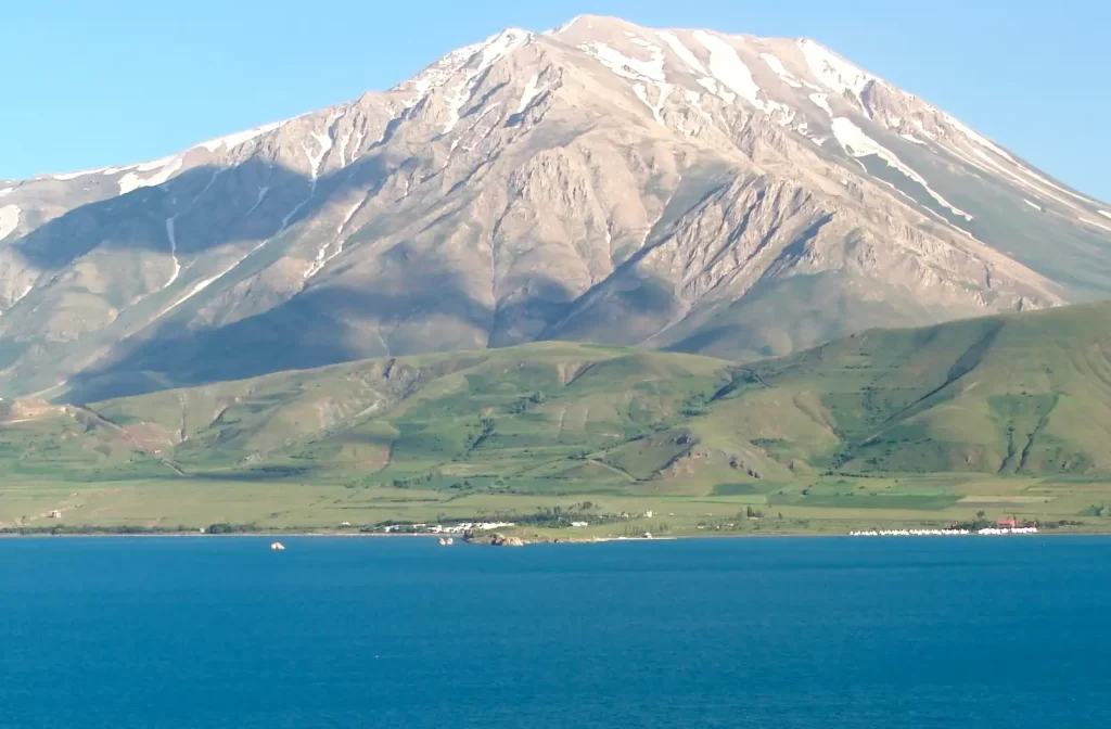
3.Mount Suphan
Where is the Mount Suphan?
Suphan is located in Bitlis city of Turkey. You can see Mount Suphan of Google Maps Please Click.
Suphan Photos of Google Photos
Click for many beautiful Google Photos and Street View 360 of Suphan
More information About Suphan
Cilo Mountain is the second highest mountain in Turkey after Mount Ararat. It is located in the province of Hakkari, which is located near the southeastern border of Turkey. Cilo Mountain, which is covered with snow that does not melt for 12 months of the year, is known as the easternmost part of the Southeast Taurus Mountains. The most important peaks of this 4,135-meter-high mountain are called Uludoruk, Suppa Durek, Kisara and Kosedireği Mountain.
For more information about Suphan, click for the website in Extremetur.
4.Mount Kackar
Where is the Mount Kackar?
Suphan is located in Rize city of Turkey. You can see Mount Kackar of Google Maps Please Click.
Kackar Photos of Google Photos
Click for many beautiful Google Photos and Street View 360 of Kackar
More information About Kackar
Located within the borders of the Black Sea Region, Kaçkar Mountain is located between Rize and Hopa. Home to a thousand and one shades of green, this mountain is literally a natural wonder. It is known that thousands of mountaineers climb the Kaçkar Mountain, which runs parallel to the Eastern Black Sea coast, every year. The highest peak of Kaçkar Mountain, which has an altitude of 3,932 meters, Altıparmak is 3,480 meters, Kavran has an altitude of 3,932 meters and Verçenik Hill has an altitude of 3,710 meters.
For more information about Kackar, click for the website in Extremetur.
5.Mount Erciyes
Where is the Mount Erciyes?
Erciyes is located in Kayseri city of Turkey. You can see Mount Erciyes of Google Maps Please Click.
Erciyes Photos of Google Photos
Click for many beautiful Google Photos and Street View 360 of Erciyes
More information About Erciyes
For more information about Erciyes, click for the website in Extremetur.
6.Mount Kucuk Agri (Little Ararat)
Where is the Mount Kucuk Agri (Little Ararat)?
Mount Kucuk Agri is located in Agri city of Turkey. You can see Mount Erciyes of Google Maps Please Click.
Erciyes Photos of Google Photos
Click for many beautiful Google Photos and Street View 360 of Kucuk Agri
More information Kucuk Agri
7.Mount Kizilkaya
Where is the Mount Kizilkaya?
Kızılkaya Mountain is a peak located in Aladağlar National Park between the provinces of Niğde, Kayseri and Adana. You can see Mount Kizilkaya of Google Maps Please Click.
More information Kizilkaya
According to past information, Demirkazık peak is known as the highest peak of the Taurus Mountains, but as a result of recent research, it is seen that Demirkazık has given this title to Kızılkaya Mountain.
There are many options to reach Kızılkaya Mountain, including Adana and Niğde.
Those who wish can reach here by going to the Aladağ district, which is within the borders of Adana. Apart from this, it is possible to reach Kızılkaya Mountain via Niğde.
For this, it is necessary to go to Çamardı district, which is connected to Niğde. Then, passing through Martı Deresi Neighborhood in Çukurbağ Village in the district, you arrive at Emli Valley. After arriving in the Emli Valley, the climbing process of the mountaineers begins. Since it is the most popular route, it is possible to encounter many mountaineers in the Emli Valley.
If you want to reach Kızılkaya Mountain via Kayseri, you need to go to Yahyalı district.
8.Mount Demirkazik
Where is the Mount Demirkazik?
Mount Demirkazik is located in Van city of Turkey. You can see Mount Demirkazik of Google Maps Please Click.
Demirkazik Photos of Google Photos
Click for many beautiful Google Photos and Videos of Demirkazik
More information Demirkazik
Demirkazık is a 3757 meter high mountain located in the Aladağlar region of Niğde. Although it was known as the highest mountain of Aladağlar for a long time, the highest peak was determined as Kızılkaya with the research carried out. On July 17, 1927, Dr. Georg Künne, Dr. The team consisting of Wilhelm Martin and Marianne Martin made the first ascents of Demirkazık (3757 m), Kaldı (3736 m), Kızılkaya (3771 m), Alaca (3582 m), Eznevit (3550 m) summits.
During the ascent of Demirkazık summit, a young villager known as Veli Sergeant from Demirkazık village guided the team. It is known that Veli Sergeant also climbed the Demirkazık summit with the team. In this sense, the first known Turkish ascent of the Demirkazık summit belongs to Veli Sergeant in 1927.
The north wall of Demirkazık mountain was climbed for the first time by Joe Friend from Australia and Rick Jamieson from New Zealand on September 15, 1972.
9.Mount Artos
Where is the Mount Artos?
Mount Artos is located in Van city of Turkey. You can see Mount Artos of Google Maps Please Click.
Artos Photos of Google Photos
Click for many beautiful Google Photos and Videos of Artos
More information Artos
Artos Mountain, which has a height of 3,550 meters, is in the Gevaş district of Van province. Artos, also known as Çadır Mountain, is a continuation of the Southeast Taurus Mountains.
Due to the nearby Van Lake, a different climate prevails on the north and south faces of Artos Mountain. There are many natural substances in this mountain, especially the sulfur mine.
Many living species, especially rabbits, wolves, bears and partridges, live on Artos Mountain. Thousands of nature lovers and botanists visit Artos Mountain every year, as 200 butterfly species are seen here in addition to the creatures in question.
In addition to its natural beauties, Artos Mountain is also known as a place suitable for mountain sports and skiing. Thanks to the altitude of 1800 meters, skiing here is a very enjoyable winter activity.
For more information about Artos, click for the website in Extremetur.
10.Mount Aydos
Where is the Mount Aydos?
Mount Artos is located in Konya city of Turkey. You can see Mount Aydos of Google Maps Please Click.
Aydos Photos of Google Photos
Click for many beautiful Google Photos and Videos of Aydos
More information Aydos
Aydos Mountain, the highest peak of the Bolkar Mountains after Medetsiz Peak, is located in the Halkapınar district of Konya. With an altitude of 3430 meters above sea level, Aydos Mountain is the 13th highest mountain in Turkey. Erciyes, Medetsiz, Hasan Mountain and Aladağlar can be seen from this summit.
Aydos Mountain, which receives strong winds, can also be reached from Ereğli district. The climb to the top of the mountain can be started from two different starting points, but both of these points are connected to the same road. It is not possible to make a technical climb to this mountain because the rock walls are not very steep. For this reason, it is preferred by mountaineers who want to do trial climbs.
11.Mount Medetsiz
Where is the Mount Medetsiz?
Mount Medetsiz is located in Adana city of Turkey. You can see Mount Medetsiz of Google Maps Please Click.
Medetsiz Photos of Google Photos
Click for many beautiful Google Photos and Videos of Medetsiz
More information Medetsiz
Medetsiz Mountain, which is included in the Bolkar Mountains, has an area that spreads to the provinces of Adana, Konya, Niğde and Mersin.
This mountain, which has a height of 3,524 meters, is tectonic.
In Medetsiz Mountain, where different climates prevail on the south and north facades, it is possible to come across vegetation of both the continental climate and the Mediterranean climate. Accordingly, steppes, hawthorn and juniper are seen on the northern face of the mountain, while cedar, black pine and red pine species are seen on the south face.
During the climb, you can also stop by the Karagöl Camping Area, which is at an altitude of 2,200 meters.
For more information about Medetsiz, click for the website in Extremetur.
12.Mount Kosedag
Where is the Mount Kosedag?
Mount Kosedag is located in Adana city of Turkey. You can see Mount Medetsiz of Google Maps Please Click.
Kosedag Photos of Google Photos
Click for many beautiful Google Photos and Videos of Kosedag
More information Kosedag
Kösedağ is located between the Zara and Suşehri districts of Sivas. It is known for having a very important place in the history scene with its altitude of 3,711 meters. The steppe vegetation dominates on Kösedağ, where the continental climate prevails due to its location. Since Sivas is located on the north-eastern side, in addition to the steppe, there are scotch pine, larch and oak forests on the mountain. As a result of its geographical structure, Kösedağ also hosts many deep valleys through which Karapınar Stream flows.
For more information about Kosedag, click for the website in Extremetur.
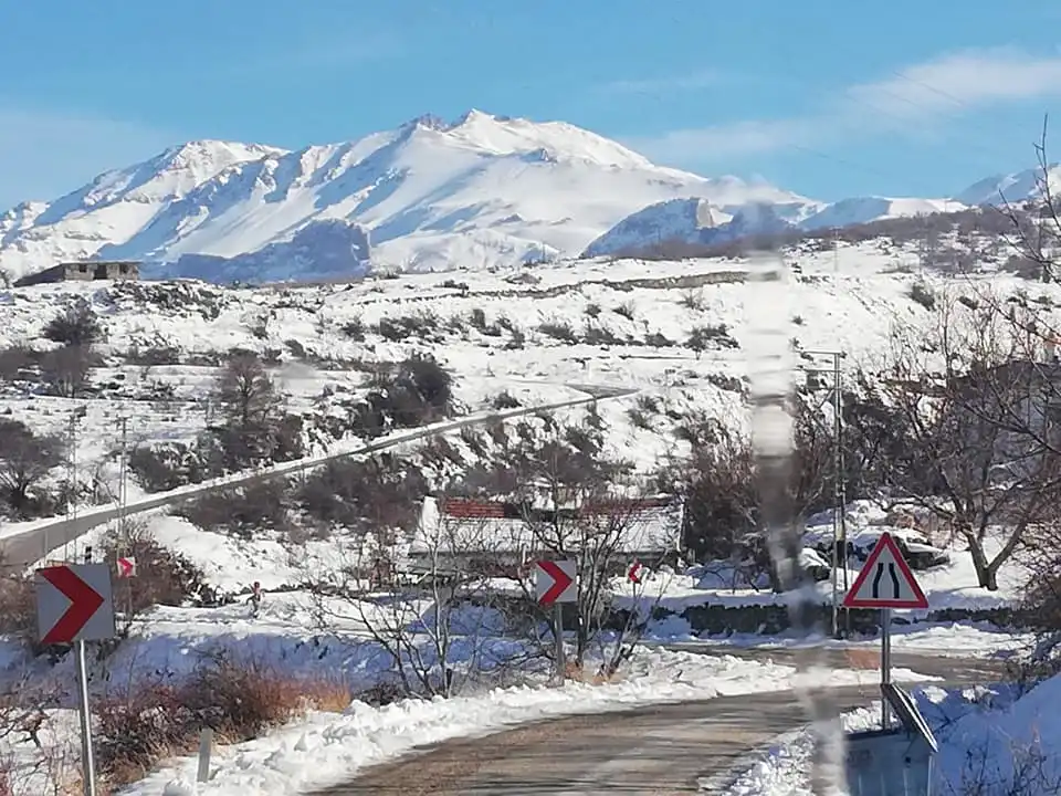
13.Mount Hasandag
Where is the Mount Hasandag?
Mount Kosedag is located in Aksaray city of Turkey. You can see Mount Hasandag of Google Maps Please Click.
Hasandag Photos of Google Photos,Videos and Street View 360
Click for many beautiful Google Photos ,Videos and Street View 360 of Hasandag
More information Hasandag
Hasan Mountain, which is the continuation of the Taurus Mountains, is located between Aksaray and Niğde.
Hasan Mountain, which has a height of 3,688 meters, is essentially known as a volcanic mountain. Hasan Mountain, which has two craters named Büyük Hasan and Küçük Hasan, dates back to BC. It is among the information obtained that it has been extinguished since 7000 years.
It holds the distinction of being the highest mountain in the Central Anatolia Region after Mount Erciyes. The skirts of Hasan Mountain, which has an extremely rich vegetation, are covered with oak forests. As you go up after the oak, the vegetation evolves into the steppe.
Nora Ancient City, dating from the Roman period, greets its visitors at the foot of Hasan Mountain, which does not only have natural beauties and has an important ancient heritage.
This mountain, which is flooded by mountaineers every season of the year, is a place with a lot of opportunities in terms of nature sports. It is possible to use public transportation vehicles going from Aksaray city center in the direction of Helvadere to reach Hasan Mountain.
For more information about Hasan, click for the website in Extremetur.
14.Mount Kisir
Where is the Mount Kisir?
Mount Kisir is located in Kars city of Turkey. You can see of Kısır from Google Maps
More information Kisir
Located within the borders of the Eastern Anatolia Region, Kısır Mountain is located in the province of Kars. To reach this mountain, it is necessary to go to Çıldır district of Kars.
Kisir Mountain, which is quite majestic with an altitude of 3,684 meters and covers a large area, is on the south side of the Ardahan basin.
This mountain, which is approximately 30 kilometers from Kars, rises dominating the hollow of Lake Çıldır in the region.
It is very rich in terms of water resources and animal diversity.
It can be seen that many large and small streams flow between Akbaba Mountain and Kısır Mountain, which are located in the immediate vicinity and extend towards the east.
For more information about Kisir, click for the website in Extremetur.
15.Mount Palandoken
Where is the Mount Palandoken?
Mount Palandoken is located in Erzurum city of Turkey. You can see Mount Palandoken of Google Maps Please Click.
Palandoken Photos of Google Photos,Videos and Street View 360
Click for many beautiful Google Photos ,Videos and Street View 360 of Palandoken
More information Palandoken
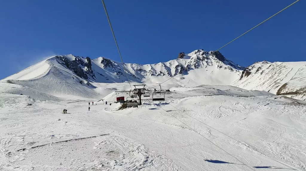
Palandöken Mountain, located in Erzurum province, stands out as one of the most popular places for winter tourism in the region, with an altitude of 3670 meters.
Palandoken, a mountain with tectonic features, is located almost 10 kilometers south of Erzurum.
This mountain, which is further south from the city, covers less area compared to other mountains at the same altitude.
The 2011 Inter-University Winter Games were held on Palandoken Mountain.
For more information about Palandoken, click for the website in Extremetur.
16.Mount Berit
Where is the Mount Berit?
Mount Berit is located in Kahramanmaraş city of Turkey. You can see Mount Berit of Google Maps Please Click.
Berit Photos of Google Photos,Videos
Click for many beautiful Google Photos ,Videos of Berit
More information Berit
Berit Mountain, located in Kahramanmaraş, is also located to the west of the Ceyhan River.
The height of Berit, surrounded by the Binboğa and Engizek Mountains, is 3,654 meters.
Due to its location, it is possible to encounter vegetation belonging to both Mediterranean and continental climates on the mountain. While there are red pine trees at the foot of the mountain, the steppe with mixed shrubs dominates as you go higher.
For more information about Berit click for the website in Extremetur.
17.Mount Nurhak
Where is the Mount Nurhak?
Mount Nurhak is located in Kahramanmaraş city of Turkey. You can see Mount Nurhak of Google Maps Please Click.
Nurhak Photos of Google Photos,Videos
Click for many beautiful Google Photos of Nurhak
More information Nurhak
Nurhan Mountain is located in the Elbistan district of Kahramanmaraş. Located exactly in the eastern part of the district, this mountain has an altitude of 3,630 meters. A town with the same name has been established on the skirts of the mountain.
It is popularly known as Nurhak or Mount Nur due to the belief that this mountain glows in the dark at night. Due to the predominantly continental climate, it is possible to see steppe and oak forests on Nurhak Mountain.
For more information about Nurhak click for the website in Extremetur.
18.Mount Sematepe
Where is the Mount Sematepe?
Mount Sematepe is located in Niğde city of Turkey. You can see Mount Sematepe of Google Maps Please Click.
Sematepe Photos of Google Photos,Videos
Click for many beautiful Google Photos of Sematepe
More information Sematepe
Located in Aladağlar, Sematepe is also known as Akkale Mountain.
It is located directly opposite Demirkazık Mountain in Aladağlar, with an altitude of 3,623 meters.
It is known for being covered with snow most of the year due to its extremely high altitude.
19.Mount Cagalinbasi
Where is the Mount Çağalınbaşı?
Mount Cagalin is located in Niğde city of Turkey. You can see Mount Cagalinbasi of Google Maps Please Click.
Cagalinbasi Photos of Google Photos,Videos
Click for many beautiful Google Photos of Cagalinbasi
More information Cagalinbasi
Located in Aladağlar, Çağalın Başı welcomes mountaineers with its 3,612 meters altitude.
The Head of Çağal, where the snow does not melt throughout the year, attracts the attention of mountaineers from all over the country and the world.
20.Mount Tendürek
Where is the Mount Tendürek?
Mount Tendürek is located in Agri city of Turkey. You can see Mount Berit of Google Maps Please Click.
Tendürek Photos of Google Photos,Videos
Click for many beautiful Google Photos ,Videos of Tendürek
It is a volcano located in the Eastern Anatolia region of Turkey. Tendürek Mountain is the 5th largest volcano in Turkey. It is located among the mountains above 3000 meters altitude. A part of Tendürek Mountain is covered with lava plateaus.
For more information about Tendürek click for the website in Extremetur.
The General Characteristics of Turkey’s Mountains
Turkey is a country with diverse mountainous regions that play a significant role in its geography and natural heritage. The major mountain ranges in Turkey can be categorized as follows:
1. Taurus Mountains: The Taurus Mountains extend along the southern coast of Turkey, forming a barrier between the Mediterranean region and the central Anatolian plateau. Divided into Eastern and Western Taurus, these mountains feature peaks such as Katrancık Dağı (3,086 m), Akdağ (3,035 m), and Bolkar Mountains (3,524 m). They are known for their rich biodiversity and support diverse ecosystems.
2. Northern Anatolian Mountains: Stretching along the northern coast of Turkey by the Black Sea, the Northern Anatolian Mountains include three main branches: Eastern, Central, and Western Black Sea Mountains. They are characterized by high peaks, deep valleys, and lush forests. Key summits include Kaçkar Dağı (3,937 m), Köroğlu Mountains (3,750 m), and Canik Mountains (3,524 m). These mountains are popular for trekking and offer stunning natural landscapes.
3. Eastern Anatolian Mountains: Located in the eastern part of Turkey, the Eastern Anatolian Mountains are characterized by high plateaus and volcanic formations. They include prominent peaks such as Mount Ağrı (5,137 m), Mount Süphan (4,058 m), and Mount Nemrut (3,050 m). These mountains provide ideal conditions for winter sports and are rich in natural resources.
4. Central Anatolian Mountains: The Central Anatolian Mountains are situated in the inland regions of Turkey, consisting of partially high plateaus and mountainous areas. They are mostly of volcanic origin, featuring notable peaks like Mount Hasan (3,268 m) and Mount Erciyes (3,917 m). These mountains are crucial for agriculture due to their water resources and offer various recreational activities for tourists.
Turkey’s mountainous regions not only provide essential ecosystem services like water supply and biodiversity conservation but also hold significant cultural and historical importance. They are home to ancient settlements, fortresses, and monasteries, reflecting Turkey’s rich cultural heritage. Additionally, these mountains contribute to the country’s tourism sector, attracting visitors with their natural beauty, outdoor recreational opportunities, and historical sites.