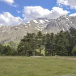
Mount Kackar
Mount Kackar is the fourth highest mountain in Turkey, with a height of 3937 meters. There are glaciers from the ice age. These are the Big and Little Glacier. Due to its unique nature and climate, it is one of the places to go every season of the year. Since it is close to sea level, it can be reached from 0 meters to 3937 meters above sea level in a short time. Therefore, a mountain peak with this feature is very rare worldwide.
Where are Mount Kackar?
The Kackar Mountains are a mountain range in northern Turkey. The mountain range on Turkey’s Eastern Black Sea coast is located in the provinces of Rize and Artvin. The peak of Kackar Mountains is Kackar Mountain, which is in the southeast Çamlıhemşin district of Rize province.
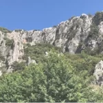
Streams descending from the northern slopes of the mountain merge and pour into the Black Sea between Ardeşen and Pazar under the name of Büyükdere. In the south, the slopes split by short streams descend steeply over the Coruh Valley. Granite-diasite crystalline rocks are located in the middle of the interbedded volcanic layers of the mountains composed of cretaceous schist and limestone. There are spruce and fir forests up to 2,000 m, mountain pastures at higher elevations, and small glaciers extending like a tongue to the north in the highest part.
How Many Meters Is The Height Of Mount Kackar Mountain?
Since the Kackar Mountains are a mountain range, the altitude changes at different points. The height of Kackar Mountain’s peak height is 3,937 meters. Therefore, it has the 4th highest peak in Turkey. For this reason, it is one of the most preferred regions in Turkey for mountaineering.
The highest peaks of Kackar mountain ranges are Altıparmak (3480 m.), Kackar (3937 m.) and Verçenik (3710 m.).
How to Go to Kackar Mountain National Park?
Kackar Mountains National Park is located in the Çamlıhemşin district of Rize city in Turkey. Kackar Mountains National Park extends to the towns of Artvin and Erzurum. The National Park is approximately 17 km away from the Çamlıhemşin district center.
If you prefer the airline, You can use Rize-Artvin Airport. You can reach Çamlıhemşin city via the shuttles departing from the airport. You can reach Kackar Mountain National Park by minibus from Çamlıhemşin.
If you prefer the highway, It is also possible to reach Rize city by bus. You can get to Kackar Mountains National Park via the Çamlıhemşin district of Rize by following the Black Sea divided coastal road. The southern part of the National Park can be reached using the Erzurum-Artvin highway, passing the Yusufeli district, Sarıgöl village, Altıparmak village, and Yaylalar Village. It is quite easy to find a vehicle as many visitors visit the city daily.
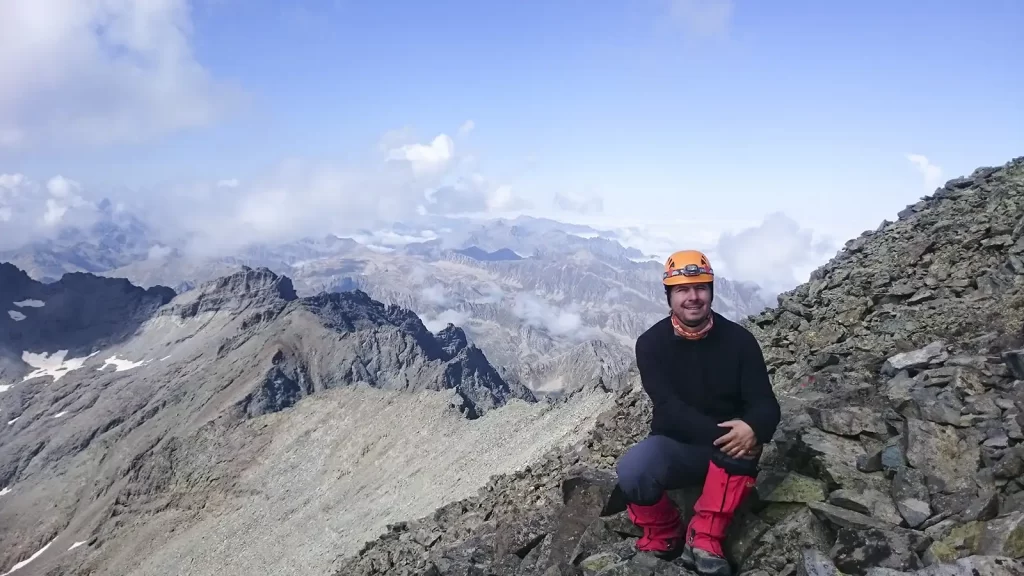
How to Climb Mount Kackar?
Kackar Mountain is one of the highest mountains in Turkey. It is also one of the most preferred mountains for mountaineering. There are many trails to climb to the top of Kackar Mountain. There are different routes, from high-altitude hiking to glacier climbing.
There are various routes, from high-altitude hiking to glacier and rock climbing, to climbing Kackar Mountain. The ways in question are basically divided into two south and north routes.
Mount Kackar Northern Routes
Three main routes are suitable for climbing on the northern face of Kackar Mountain. These are the north classical (ridge route), small glacier, and extensive glacier routes. Thanks to the large and small glacier routes, Kackar Mountain is one of the limited mountains where glacier climbing can be done in our country. Therefore, this mountain is summer and winter. It attracts many mountaineers.Northern routes start from Yukarı Kavrun Plateau, which is 17 km away from Ayder Plateau in Rize Province, Çamlıhemşin District.After reaching the Upper Kavrun Plateau, you reach the place known as the embankment by moving in the southeast direction. After the set, at an altitude of approximately 3000 m. It is reached to the ox meadow region, located in Climbs, which are technical climbs and glaciers, rock and m ix require equipment suitable for climbing techniques and mountaineering training.
Mount Kackar Southern Route
The route to the day, known as the most straightforward route of Kackar Mountain, starts from the Yaylalar Village of Artvin Province, Yusufeli District. Then, proceeding in the southwest direction along the valley, first to the Olgunlar Plateau and then to the Nastaf (Hastav, Hastaf) plateau, at an altitude of 2900 m, the area called “Dilber Plain” is reached. Dilber Plain is the main campground of the Kackar southern route. Then, it starts by climbing to Deniz Lake. From here, the summit is reached by following the path and signs in the northwest direction. The southern route is the longest of all the ways of Kackar Mountain and the safest in summer conditions. Since there is no snow or ice on the route in summer, there is no need for crampons and technical digging. On the other hand, climbing in winter is very dangerous due to the high avalanche risk due to slope, vegetation, and aspect.
Altiparmak Mountain Route
When the climb starts from the north, Ayder and Dutha plateaus are passed. Camps are set up from the Agveçur, Kackar and Zigam springs and the summits of Karataş (3492 m.) and Altıparmak (3480 m.) are reached. Those who start the climb from the south come to Altınparmak Barhal village from Erzurum by car. From here, they reach Karagöl campsite on foot in 5 hours. Each climber reaches the desired peak from the camp according to their technique.
Which Times Are Suitable for Mountaineering Activities in Kackar?
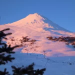
Mountaineering activities are in high demand in the Kackar Mountains. For this reason, seasonal conditions are more suitable for mountaineers. The best time for those who prefer summer climbing is August and September. For those who prefer winter climbing, February and March are more suitable.
Is Mount Kackar a Volcanic Mountain?
Kackar Mountain contains cretaceous schists and limestones in its layers. There are moraines near the glacier. For this reason, Kackar Mountain is considered an interbedded volcanic mountain.
Is There a Glacier on Kackar Mountain?
Kackar Mountain is one of the highest altitude mountains in its geography. For this reason, the glaciation in the Pleistocene period also showed its effect on Kackar Mountain. Glacial traces on Kackar Mountain can be seen at 2000 meters north and 2200 meters south. Kackar Mountain is one of the essential glacial areas in Turkey. Over time, the remaining large glaciers of the Pleistocene period remained at the bottom of the boat valleys.
How were the Kackar Mountains Formed?
Kackar Mountains are mountains formed by bending and breaking. For this reason, pitted parts in the form of boats were created in the earth’s crust. Over time, lakes were formed in these parts. The glacial lakes on Kackar Mountain are an example of this.
Where Does the Name of Kackar Mountains Come From?
It is thought that the name of Kackar Mountain comes from the word “Haçkar”, which means “Crossed Stone” in Armenian. According to another claim, it is thought that it came from the word “Koçkar”, which means “Koç” in Kipchak Turkish, and turned into “Kackar”, which is its current form.
What Are the Tourist Attractions Near Kackar Mountain?
Kackar Mountain attracts the attention of visitors with its unspoiled nature. The fact that there are different areas to visit for visitors to Kackar Mountain is another reason it is preferred. Guests who come to Kackar Mountain can participate in activities such as mountaineering, camping, trekking, skiing, rafting, and rock climbing in addition to their trips. At the same time, visitors to Kackar can have the opportunity to spend time in the highlands.
Pokut Plateau, Tatos Lakes, Upper Kavrun Plateau, Marbudam Plateau, Diberdüzü, Galer Plain, Kito Plateau, Büyük Deniz Lake, Şen Yuva Village, Zilkale; Kackar Mountain is one of the most visited places around it.
Is There Accommodation Opportunity On Mount Kackar?
There is also an accommodation opportunity in Kackar Mountains National Park. Visitors who want to stay in the Kackar Mountains can stay in the surrounding plateaus. Generally, Ayder Plateau is one of the most preferred regions. There are hostels, boutique hotels, and bungalows for accommodation in Ayder Plateau. There are many accommodation options. For this reason, finding different accommodation options suitable for every budget is possible. In addition, the hot springs in the region are also a source of healing.
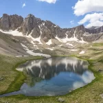
Mount Kackar Glacial Lakes
There are about 100 glacial lakes in the Kackar Mountains, on which there are current glaciers.
Sea Lake
It is the largest glacial lake of the Kackars, with an altitude of 3375 m and an area of 750 m². It is approximately 150 m in diameter and 60 m in depth. The ice layer in the lake, whose surface has been covered with ice for ten months, begins to melt between 17-25 July. Since it is on the way to the summit of the Kackar Mountains, it is a frequent destination for mountaineers in summer. It can be reached by walking for 5-6 hours from the Olgunlar District of the Yaylalar Village of Yusufeli district.
Black Sea Lake
Çeymakçur is located in the glacial valley. It is 2 hours walking distance from Ayder Plateau, at an altitude of 2800 m.
Seven Lakes
They are located at an altitude of 3100 m in the Verçenik Mountains southwest of the Kackar Mountains. It is located in the Çayırözü area on the Erzurum-Rize border. It consists of 10 lakes, some very small, within the boundaries of İspir. It can be reached after a 1-2 hour walk from the end of the 21 km stabilized road from the Çayırözü district. Anzer and Cimil plateaus are located in the north of the lake region.
Black Lake
It is the largest of the 14 glacial lakes in the Altınparmak Mountains, the eastern part of the Kackar Mountains. It has a width of 130 m, a length of 230 m, and a depth of 7 m.
Gated Lakes
It is in the form of two interconnected lakes at the foot of the Verçenik Mountains. It is on the 2-3 hour walking path after Verçenik Plateau. This name called them because the passages on the summits of the mountains between Erzurum and Rize are called gates.
Horse Lake
It is between Verçenik Plateau and Kapılı Lakes. Verçenik Stream rises from the lake. Glacial lakes do not live very much due to their height, but those left in the At lake survived, and there are trout in the lake.
Tatos Lakes (Wet Lakes)
It is located on the slopes of Tatos Mountain, at an altitude of 2900 m, in the form of three interconnected lakes. A 3-hour walk can reach it from the Verçenik plateau.
Lake Salar
It is located in the Çermeniman glacial valley in the Çapans Mountains. It is located at the bottom of the raft breach, and its length is 500 m. Within the glacial valley are also Lake Salar, Lake Cin, and Domed Lake.
Cin Lake
The Capans Mountains are located in the Çermeniman glacial valley. It is situated in a hanging valley on the west-facing slopes. Its waters feed the Ziyaret Creek.
Şefkar Glacial Lakes
They are found in circuses in the Capans Mountains, in the Sarpinovit Glacial Valley, with a base height between 3100 m and 3150 m.
Devil’s Lake
In the Çapans Mountains, glacial lakes were formed in the circuses in the high areas within the Kuruyatak glacial valley. Devil’s Lake, Çürük Lake, and Çikrik Lakes are among them. Devil’s Lake attracts attention with its pyramidal conical hill over 3000 m north.
Moses Lake
Verçenik Mountain is a glacial lake with a diameter of 200 m, at an altitude of 3035 m, in the Cimil valley. The waters coming out of the lake are poured into Çatak Creek.
How much are the Maount Kackar tours?
There are many tours with different concepts and contents organized for Kackar Mountain. Tour and climbing prices average between $400 and $700.
The Legend of Mount Kackar
In the Kackar Mountains, in the region known today as the Blind Ahmet Plateau, a young man with a defective eye used to be. For this reason, the young man was called Blind Ahmet. According to the legend, Ahmet used to climb up to the hills close to the peaks of the Kackar Mountains every day and hunted wild goats that roamed in herds in this region. Ahmet was an excellent hunter, even though he couldn’t see in one eye. Every time he went hunting, he would hunt a mountain goat. Moreover, Ahmet was a very generous young man. He took as much as he needed from the goats he hunted and shared the rest with the poor. For this reason, the villagers loved Ahmet very much.
He used to climb Ahmet Kackar in every season and weather, and he always hunted for something. That’s why everyone was waiting for Ahmet’s return when Ahmet went to the mountain. One day, Ahmet returned from the mountain empty-handed. As the days passed, Ahmet kept returning from the mountain empty-handed. This situation started to make Ahmet uneasy. One day, one of the elders in Ahmet’s village told Ahmet, “Wild goats are following the haunted girl. The haunted girl is taking the goats away from you.” After that, listening to the older man, Ahmet got ready again and went to the mountain. He ambushed the haunted girl.
As it was morning, he saw the Haunted Girl and the goats following her. The haunted girl took the goats to the water’s edge. Ahmet took aim at the goats that were preparing to drink water from the lake and started shooting one by one and killed the goats. Seeing this, the haunted girl was distraught by the death of the goats and shouted to Ahmet, “Don’t do it…”. But Ahmet continued to shoot. Then the fairy girl called to Ahmet, “May you be a stone, Ahmet!” Then, Ahmet suddenly turned into a stone. After that day, even fish could not live in the lake where the goats drank.
Blind Ahmet Pass is located where this legend takes place. Guests coming to Kackar Mountain come to Blind Ahmet Pass to see the stone-cut silhouette of Blind Ahmet.
You can follow the current weather conditions for Mount Kackar on this site.
The mountain of the mountains, Mount Ararat may also interest you. Please click to read.