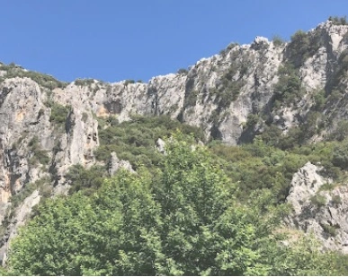
Gokdere Rock Climbing Zone
Although Gokdere Rock Climbing Zone is located close to the city, its natural environment is a very beautiful place. There is a stream flowing through the mountains and a camping area. You can see Photos Gokdere of Google Photos.
Where Is The Gokdere Rock Climbing Zone
Gökdere is a neighborhood of İzmir Bornova district, but it is also close to Buca district. A place very close to Izmir. You can reach by car or by bus number 277 from Otogar-Tınaztepe or by the Kaynaklar minibuses departing from near Buca Hasan Ağa Park. You can see Gokdere Rock Climing Zone of Google Maps.
In which season can you go to Gokdere?
Since the climate of the region is Mediterranean, it can be visited in four seasons. In winter and spring, water flows in streams.
Are there walking paths?
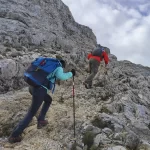
In a wonderful place, in the lush forest, there are 6 km of paths on the path.
A very nice track: Kaynaklar – Gökdere Canyon ;
It starts from the village of Buca Kaynaklar. All kinds of needs can be met in this village. You can find local organic products, keskek, pancakes, village bread, village eggs and many other field and garden products, vegetables and fruits in the stands opened by village women. Crossing the wooden bridge and climbing the path in the stream under the climbing cliff, under the shade of pine and plane trees, you can reach Gürlek Locality. From here, you can reach TEKÇAM by following the forest road. Follow the forest path descending from Tekçam to Gökdere Canyon.
Here, too, the Gökdere Canyon valley is descended from the banks of the stream in a valley covered with lush pine and plane trees. Enter the pathway starting from the fountain at the end of the forest road . After walking 500 meters from the path, you reach the fountain with cold and abundant water. You can reach the Gökdere Picnic area at the exit of the canyon without seeing the sun under the pine and plane trees. The road continues on the path that turns south from the picnic area and continues to Kaynaklar village. With a brisk walk of approximately 2.5 hours, Kaynaklar Çınaraltı is reached from the fountain head.
Source and for route for You can visit the tr.wikiloc.com
You may also want to learn about Turkey’s highest mountain, Mount Ararat. Please click on the link to read more about majestic Mount Ararat.