

Taurus Mountains Aladaglar
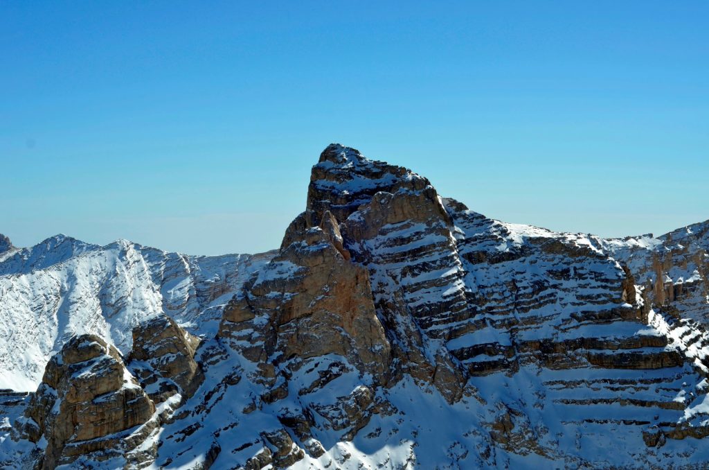
Taurus Mountains Aladaglar are mountain ranges located between the cities of Niğde, Adana and Kayseri. They form the central part of the Taurus Mountains, which is part of the Alpine-Himalayan fold. There are about 60 peaks above 3000 meters in Taurus Mountains Aladaglar, Kızılkaya (3771 m), the highest peak of the Taurus Mountains, is also located here.
Taurus Mountains Aladaglar is a mountain range also known as Turkey’s Alps. The remarkable features of this mountainous region are its high peaks, various activities it offers, and the biodiversity here. With these features, Taurus Mountains Aladaglar is undoubtedly one of Turkey’s magnificent and must-see geographies. The mountainous and high geography of Taurus Mountains Aladaglar makes it one of the most important regions where mountaineering activities are carried out in Turkey.
How to Go to Taurus Mountains Aladaglar?
There are different ways to go to Aladag National Park. It is possible to reach Adana, Kayseri and Niğde by road, railway and airway. After arriving at Adana or Kayseri airports, it is possible to reach the National Park from the Çamardı district of Niğde.
Another transportation point is possible via Demirkazık village. Çamardı buses from Niğde and Adana can be used for this route. Kayseri Yahyalı is another transportation point.
What Activities Are Done in Mount Aladaglar ?
Outdoor sports such as mountaineering, rock climbing, long nature walks, touring skiing and mountain biking can be practiced in the region. In addition to nature sports, bird watching in Taurus Mountains Aladaglar is also among the activities. Camping in the camping areas of this National Park region and witnessing the magnificence of the mountains are not only for those who do outdoor sports; Those who want to spend time in nature and see the magnificence of this region can visit Taurus Mountains Aladaglar National Park.
In Kazıklı Ali Canyon, located at the entrance of the Emli Valley of Taurus Mountains Aladaglar, there are many sports climbing routes where rock climbing can be done. Kazıklı Ali Canyon of Taurus Mountains Aladaglar is also one of the most convenient areas for rock climbing in Turkey during the summer months.
What are the places to visit inTaurus Mountains Aladaglar?
Taurus Mountains Aladaglar National Park Long Term Development Plan studies were started in 1998. The area of the national park is 54.524 hectares, and this area is located within the civil borders of three provinces (Kayseri-Adana-Niğde). Approximately 31.000 hectares (2/3) of Taurus Mountains Aladaglar National Park is located in Yahyalı district. The total area covers 54524 hectares and 31,358 hectares within the borders of Kayseri province.
It is located in Taurus Mountains Aladaglar National Park in places that have natural resource values such as Demirkazık Hill, Seven Lakes, Hacer Forest, Kapuzbaşı Waterfalls and Acısu, which attract the attention of tourists.
Demirkazık Hill:It is within the borders of Niğde province. In the Central Taurus Mountains, it is frequented by mountaineering tourists and the Taurus Mountains are the second highest peak of Aladağlar National Park. (3757 m) is among the most important elevations of our country.
Yedi Göller : It is located within the borders of Kayseri Province, within the Taurus Mountains Aladaglar National Park. Yedigöller locality is at an altitude of 3500 m, and there are 7 lakes of great and small importance. The lakes are fed by rain, snow and glacial waters.
Hacer Ormanı: It remains within the borders of Kayseri province. Hacer forest is around 2750 ha and has a bowl-shaped and calcareous soil structure. There are tree species such as larch (Posçamı) predominantly red pine, fir, cedar, aspen and juniper. In addition, there is a field where tourists can camp and take a break in the cold spring area.
Kapuzbaşı Waterfall remains within the borders of Kayseri. 80 km from Yahyalı district. 190 Km. to Kayseri Province. It is 50 km from Taurus Mountains Aladaglar District. 150 Km. to Adana Province. and 160 km from Nigde province. The altitude of the waterfalls is 730 m. There are 7 waterfalls here and the altitude flow of the biggest waterfall is from 86 m. Its flow rate is quite high and it flows into a “V” shaped valley. It is fed by snow and glacial waters in Yedigöller locality in Aladag Mountains.
How many peaks are there in the Mount Aladaglar?
Aladag Mountains are mountain ranges located between the cities of Niğde, Adana and Kayseri. They form the central part of the Taurus Mountains, which is part of the Alpine-Himalayan fold. There are about 60 peaks above 3000 meters in Aladag Mountains.
Nature and Mountain Tourizm
Niğde is an important center for mountaineering and winter tourism. TTaurus Mountains Aladaglar and Bolkar Mountains are of great importance in terms of mountaineering, trekking and winter sports. There are four elevation groups in the Taurus Mountains Aladaglar, which has the status of a national park. Demirkazik is 3757 meters. Kızılkaya is 3771 meters high. The highest peak of Kaldı Mountain in the Kaldı group is 3688 meters. The highest peak of Vayvay Mountain in the Torasan group is 3565 meters.
Tours And Climbings In Taurus Mountains Aladaglar
Researchers and mountaineers, who will make trips and climbs on the Taurus Mountains Aladaglar, usually enter the Taurus Mountains Aladaglar via the Niğde-Çamardı-Çukurbağ village. Those who want to climb only Demirkazık peak of the Taurus Mountains Aladaglar can enter the Taurus Mountains Aladaglar from Demirkazık village. Both Çukurbağ and Demirkazık villages are connected to Niğde city center through Çamardı state. Niğde- Çamardı road (65 km) is used to reach Çukurbağ village. The road is asphalt. Passengers using the Niğde-Çamardı buses land in Çukurbağ village, which is on the highway 6 km before Çamardı. After the necessary preparations are completed here, the entrance to the Taurus Mountains Aladaglar is made.
However, mountaineers who want to climb Demirkazık and some mountaineer groups who want to rest pass to Demirkazık village. The distance between Çukurbağ and Demirkazık villages is approximately 5 km. The road is stable. In Demirkazık village, a mountain hotel with 100 beds and central heating is open all year round. Again in the same region, a new hotel (run by the Provincial Directorate of Youth and Sports) was put into service in 2002. This place has the capacity to meet all kinds of accommodation needs.
According to the natural environment and climatic conditions, the best time for excursions and climbing activities on the Taurus Mountains Aladaglar is June, July and August. Researchers and mountaineers, who will make trips and climbs on these mountains for the first time, need to be prepared to be protected from the intense “sunshine” seen effectively in the whole mountainous region. Light-colored, cotton clothing is used during excursions and climbing.
Excursions and climbing on the Taurus Mountains Aladaglar are generally implemented in four parts. These trips and climbs are programmed as Demirkazık, Yedigöller, Kaldı and Turasan climbs, respectively. These excursion and climbing programs can also be applied from south to north as Kaldı-Turasan,
Yedigöller and Demirkazık programs
Mountaineers who will travel and climb on the Taurus Mountains Aladaglar, where steep and high peaks are located side by side, should do even the most insignificant trips and climbing related to this mountainous region and the high peaks on it, very seriously and carefully. In this high mountainous region, which is spread over a wide area, transportation, first aid and rescue activities can be carried out under very difficult and difficult conditions or not at all. For this reason, it is necessary to strictly stay away from behaviors that may cause an accident on the mountain.
Demirkazik Climb (3757 m.)
Demirkazık’s first summer ascent was made on 17 July 1927 by Dr. It was made by G. Künne and his team. The honor of the first winter ascent to Demirkazık peak belongs to Turkish mountaineers. Demirkazık made his first winter debut on February 29, 1969 by Dr. It was carried out by Bozkurt ERGÖR and Sönmez TARGAN. For climbing Demirkazık, the wonderful peak of the Aladag Mountains, the Sokulpinar campsite is generally used, and there is always water at the campsite. Sokulpinar camp site is approximately two hours away from Çukurbağ and Demirkazık villages on foot.
Normal climbs to Demirkazık summit from southeast and south slopes and “Western slope climbing”, which have technical features, are made from this camp site. The Narpuz valley is used for normal climbing over the southeastern and southern slopes of Demirkazık. When it comes to the middle part of this valley, by turning north, the summit is reached over the southern slope. If desired, the hike can be continued until the end of the Narpuz valley. At the end of the valley, the “Kızılçarşak” is crossed and the neck is reached. The summit is reached by following the southeast ridge of the ridge leading to the summit. After the summit exit, you can reach the campsite again from the exit road. Under normal conditions, peaking takes 8-10 hours. Some teams make intermediate camp at 2500 meters after entering the Narpuz valley and crossing a narrow gorge. Known as Kayacık and located on the right slope of the valley, there is always water in this section.
Climbing Demirkazık Peak from the West and North Slopes
Climbing to Demirkazık summit from the western and northern slopes requires technique and experience. Especially mountaineers who do not have rope and spike climbing techniques should not have the enthusiasm to climb in these directions. Sokulpınar campground is used for climbing Demirkazık from the western slope. Each climber determines the climbing path according to his own technique and experience.
To climb Demirkazık from the northern slope, cross the Çımbar valley over the Arpalık-Çımbar strait. An intermediate camp is set up here. Sokulpınar-Çımbar valley takes 4-5 hours on foot. The mountaineers who camp in the Çımbar valley determine their own climbing routes. Demirkazık northern slope climbing is generally more difficult than western slope climbing. Climbs are generally in 4-6 difficulty levels. Climbing from this direction, the mountaineers descend to the Sokulpınar main camp site over the Narpuz valley, following the southeast ridge, or again to the Çımbar valley from the neck on Kızılçarşak.
Peak Exits from Yedigöller Valley
To pass to the Yedigöller valley (3100 m), you can take a walk from Çukurbağ village or Sokulpınar campsite. It takes about 2-3 hours to reach the mouth of the Yalak valley. The walk continues along the Yalak valley, ascending to the east. At the end of the valley, you can reach Çelikbuyduran Spring by turning north. Here is a nice break. After the break, the neck behind is crossed and the beginning of the Yedigöller valley is reached. After a descent that takes about 1 hour, you come to the lakes region at an altitude of 3100 meters. A camp is set up on the edge of the big lake. You can reach the Yedigöller campsite from Çukurbağ with a walk that takes about 8-10 hours.
Yedigöller has its own unique climatic conditions. Due to the altitude, the waters freeze at night at the Yedigöller valley camping site. In the daytime, intense radiation (sunbathing) occurs. Mountaineers especially need to protect themselves due to the 25-30 degree temperature difference between night and day.
Kızılkaya Climb from Yedigöller Valley (3771 m)
Kızılkaya is the highest peak of Aladağlar with 3771 meters. The Kızılkaya peak rises to the southwest of the Yedigöller valley. Kızılkaya, whose northern part is very steep and high, is the highest peak of Taurus Mountains Aladaglar. At the base of the northern wall of the Kızılkaya peak, there is a still active icicle bowl, and inside this bowl is a very beautiful glacial lake “Şirin Göl”. At the northeast end of Şirin Göl, there is an active Moraine barrier.
There are different ways to climb to Kızılkaya peak with different difficulty levels. Each climber determines his own climbing path. For this, every mountaineer should make a study trip. For a safe and comfortable ascent to the Kızılkaya peak (3771 m), you can start from the campsite.
The climb starts from the left of “Şirin Göl” of Kızılkaya glacier lake and climbs to Kızılkaya peak ridge at an altitude of 3500 m. To the east of this NS-trending ridge, from which the summit climb started, two core glacier beds are seen.
Climbers reaching the Kızılkaya ridge reach the Kızılkaya peak (3771 m) by continuing the ascent from the west and the southern part of the ridge. It takes about 5-6 hours to climb Kızılkaya from this road. The return cannot be made the same way. On the way back, one descends to the Celikbuyduran ridge from the southwestern slope of the mountain. From there, we go back to the camp site in the Yedigöller valley. It takes about 3-4 hours to return to the campsite from this road.
Climbing from Yedigöller Valley to Direktaş Hill
At an altitude of 3510 m, Direktaş peak rises southeast of the campsite. Normal ascents to the Direktaş ascent are made from the south face. For the summit climb, the hike starts from the campsite. After a 20-30 minute walk, you come to the south of the mountain, in front of the lane, which is the peak and the beginning of its ascent. From here, the summit climb begins. It takes about 3-4 hours to reach the summit and return to the camp from the same road.
Demirkazık Climb from Yedigöller Valley
Mountaineers hiking in the northwest direction from the Yedigöller camp site reach a gorge that provides a passage to the Narpuz valley. From here, the climb to the top of Demirkazık (3757 m) begins by descending into the Narpuz valley. Climax ascent and return are made through the Narpuz strait via the normal route, the end of which is stated before. Mountaineers who ascend Demirkazık from this route normally return to the camp within the same day.
Trans – Taurus Mountains Aladaglar Pass
Mountaineers who have completed their excursion, research and climbing on Yedigöller can make a Trans-Taurus Mountains Aladaglar trek by passing “Ulupınar” to Barazama via Hacer Strait from here. The Yedigöller-Barazama crossing takes about 5-6 hours. Mountaineers doing the Trans-Taurus Mountains Aladaglar trek descend to Adana (approximately 120 km) by the Barazama-Karsanti highway.
The Trans-Taurus Mountains Aladaglar or “Trans-Taurus” trek is made in the direction of Barazama-Yedigöller-Çukurbağ or Çukurbağ-Yedigöller-Barazama. Mountaineers who finish their excursions and climbs on Yedigöller, if they will not do the “Trans-Taurus” trek, pass to Kaldı Mountain on the Yalak valley. This walk between Yedigöller and Aksampınarı takes about 8 hours.
Climbing Kaldı Mountain (3688 m)
Kaldı Mountain, at an altitude of 3688 m, rises in the south of Taurus Mountains Aladaglar. For climbing Kaldı Mountain by the normal way, a camp is set up in the Sıyırma gorge in the Emli valley for climbing to Akşampınarı from the north.
Climbing Kaldı Mountain by the Normal Way
The climb starts from the Akşampınarı camp site. Continuing the climb in the south direction, you come to the place called “Avcıbeli”. From here, the climb continues in the east direction, and first the “Kaldıbaşı” hill and then the Kaldı peak (3688 m) are reached. The return is made the same way. It takes 8-10 hours to peak and return from this direction. Technical climbs to Kaldı Mountain are generally made over the northeast and north ridges. The stripping throat was used as a camp site.
Güzeller and Gürtepe Peak Departures
In the northeast and east of the Emli valley, Cebel Mountain (3630 m), Gürtepe (3474 m) and Güzeller peak (3461 m) rise. Mountaineers who want to climb these peaks camp at the Sulağankeler plateau at the Sıyırma gorge, which is the end of the Emli valley. From this campsite, beautiful and enjoyable climbs are made to peaks such as Güzeller, Gürtepe, Cebel and Özgüdek (3620 m). It is also possible to pass through the Turasan mountains from this campsite.
Climbing the Torasan Mountains
Turasan and Torasan mountains, located in the southeast of Taurus Mountains Aladaglar, require a special excursion and climbing program in terms of road transportation and peak climbing. For the exits of Boruklu Tepe (3548 m) and Vayvay Tepe (3565 m) located on these mountains, it is possible to pass through the Sıyırma valley, as well as through the Yedigöller valley. Mountaineers crossing the Sıyırma valley-Sulağankeler plateau camp in the Kokorot valley, while mountaineers crossing the Yedigöller valley camp in the Karagöl valley. Those who want to come to the Turasan mountains via Adana, first go to Acıman (Tırak) plateau via Karsanti-Kökez village. Adana-Karsanti is 75 km away, and Karsanti-Acıman plateau is approximately 40 km. It is possible to reach Vayvay Tepe camping site from Acıman (Tırak) plateau with a 6-7 hour hike. Mountaineers who want to hike and hike on the entire Taurus Mountains Aladaglar should enter these mountains through the village of Niğde-Çamardı-Çukurbağ. Only if they are going to travel or climb on the southern Taurus Mountains Aladaglar and Turasan mountains, they have to enter especially through the Adana-Karsanti-Kökez village. they encounter a wildlife and natural pattern. In addition, during this trip, there is the opportunity to examine Kapuzbaşı Waterfalls, which is the exit point of the underground Karst Streams, which are unique to the Taurus and Mount Aladaglar.
When to go to Mount Aladaglar?
The best time to visit Taurus Mountains Aladaglar (if not for winter mountaineering) is from mid-May to September. First of all, although it is summer, we should state that the geography of Taurus Mountains Aladaglar offers variable weather and cold and rainy weather is encountered especially in regions above 3000 meters.
As of May, spring comes to Taurus Mountains Aladaglar , flowers bloom and nature comes to life.
As of June, the snow at high altitudes becomes icy and favorable conditions for lane climbing are created. Snow-covered areas are still found high up in July, and occasional rains and electrical storms also occur. In August, except for permanent glaciers, snow and ice melt thoroughly. In July, August and September, snow only occurs in places that do not see the sun.
In June and July, there is no shortage of water resources in the high camping areas, but with the drought of August, the water resources begin to dry up. After mid-September, water resources begin to decrease. For this reason, information about the condition of the camp sites and water resources should always be obtained from the local people while planning the activity.
Towards the end of December, permanent snow begins to fall on Taurus Mountains Aladaglar. The ideal time for winter mountaineering is from the end of February to the end of March.
You can follow the current weather conditions for Taurus Mountains Aladaglar this site.
The mountain of the mountains, Mount Ararat may also interest you. Please click to read.