Bey Mountains
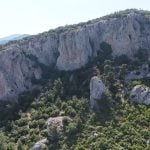
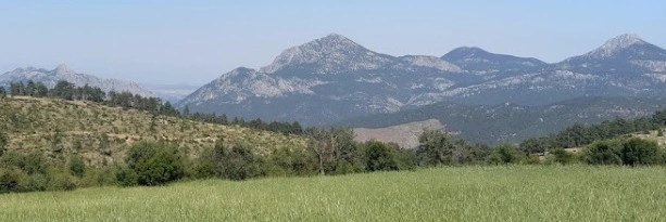
The Bey Mountains in Antalya, Turkey, are a majestic mountain range that extends in a north-south direction parallel to Antalya Bay. These mountains offer a range of activities for geologists, archaeologists, and tourists alike. From mountain climbing to archaeological exploration, there is something for everyone.
The Bey Mountains: A Haven for Geologists, Archaeologists, and Tourists
One of the highest peaks in the Bey Mountains is Kizlar Sivrisi, with an elevation of 3086m. It is a popular destination for mountaineers who want to climb to the summit in a day. The climb starts from Çamçukuru Valley, which is covered in cedar forests. Another popular peak is Tahtali Mountain, with a height of 2360m. It is situated to the west of Kemer and boasts of interesting slopes that are covered in pine and mixed forests up to 2000m high. Mountaineers who want to climb Tahtalı Mountain can start from Soğukpınar and witness unique views by climbing over the ridges overlooking the Mediterranean. It is also possible to reach the summit by cable car.
Aside from mountain climbing, the Bey Mountains are also a haven for geologists.
Moreover, the Bey Mountains are also home to numerous historical ruins. Archaeological remains were discovered in the Bey Mountains by Akdeniz University’ lecturers from 1997 to 2006. Since 2007, many ancient cities such as Trebenna, Neapolis, Kelbessos, Onobara, Typallia, Kithanaura, Mnara, and hundreds of ancient farms and garrisons were identified and published respectively. The Bey Mountains ruins cover the eastern Lycia and SW Pisidia cultural regions.
Tourism in the Bey Mountains
The Bey Mountains offer an excellent opportunity for tourists to explore the historical ruins, mountain climb, and study the geology of the area. Excursions to the Bey Mountains can be organized throughout the year, but the months of April, May, and June are more suitable due to the suitability of the climate and the period when the flora richness of the region appears. Additionally, recent developments in mountain tourism, trekking, and amateur mountaineering from Alanya have started to show, especially in Akdağ (2451m north-east) and Cebelireis Mountain (1649m in Dim region). Akdağ has been declared a “Winter Sports Tourism Center” by the Turkish Ministry of Culture and Tourism.
In conclusion, the Bey Mountains in Antalya, Turkey, offer a range of activities for geologists, archaeologists, and tourists alike. From mountain climbing to exploring historical ruins, the Bey Mountains provide a unique experience for anyone who visits. If you are interested in mountain climbing, studying geology, or exploring historical ruins, the Bey Mountains should definitely be on your list of places to visit.
You can see Bey Mountains on Google Maps
Notes:
He has a truly impressive nature. Although it is very close to Antalya, it is a very cold region due to its altitude. There is a generally secluded settlement. You can come for a walk. Dress thickly.
You think this is the heart of nature, it gives this feeling.
A magnificent region that truly fascinates with its natural beauty and air
ONE OF THE WORLD’S MOST BEAUTIFUL 10 WALKING ROUTES
Used by the Lycian civilization and its roots date back to BC. IV. The historical Lycian road dating back to the 16th century is a magnificent walking track intertwined with nature and history. Considered one of the 10 most beautiful walking routes in the world, the Lycian Way has a length of 509 kilometers, starting from Antalya and ending in Fethiye. 125 kilometers of the road is located in and around the Beydağları Coastal National Park.
IT IS POSSIBLE TO SEE THE REMAINS OF ANCIENT CITIES
In the middle of the ancient city, there is a magnificent street 20-24 meters wide. At the southern end of this street is Hadrian’s waterway gate. Some of the aqueducts carrying water to the city, the walls built for protection on the sea side, the ruins of the agora and baths are located in the ancient city. In addition, the gate, which was built in honor of Emperor Adrian’s arrival in the city, is evident even though it has been demolished. The streets and theaters in the ancient city are still used in a controlled manner today to organize cultural events. Excavations have not yet been carried out in the necropolis and temple part of the city.
ANCIENT CITIES OF OLYMPOS, PHASELIS, IDYROS
Beydağları Sahil National Park, located in the east of the region known as Lycia in ancient times, has been used as a settlement area since prehistoric times. Especially the finds in the Beldibi Cave, located in the north of the coast, are shown as the greatest proof that this region was used for settlement. The ancient cities of Olympos, Phaselis and Idyros are located on the long and unique beach in the national park between the Pamphylia and Lycian coasts. B.C. VII. The city, which was founded by the Rhodians in the 16th century, was used as the most important port of the eastern coast of Lycia for many years. Phaselis, which has a total of three ports, namely the North Port, the War or Protected Port and the Sun Port, is the most important port in the south.
You may also want to learn about Turkey’s highest mountain, Mount Ararat. Please click on the link to read more about majestic Mount Ararat.