Nur Mountains
The Nur Mountains, also known as Gâvur Mountains or Amanos Mountains, are a range of mountains that extend from the Sır Dam Lake in Kahramanmaraş to the Samandağ coast in Hatay, covering a distance of 175 km. The majority of the mountains are covered with moist forests similar to those found in eastern Black Sea region.
The Nur Mountains: Intersection of Culture and Nature
The original name of the mountains could not be pronounced by the locals because it was a foreign name, and therefore the people referred to it as Gâvur Mountains, a name that has been in use for almost a thousand years.
Amanos Mountains, on the other hand, is both a place and mountain name that appears in Hittite and 2nd millennium BC Syrian texts. The kings of Babylon and Assyria were in need of the “Sedr forests” of the Lebanese Mountains (Amanos) and the Silver Mountains (Taurus), which were deprived of stone and forest. This is why the “Sedr” forests (Amanos) and the Silver Mountains (Taurus) have been mentioned in connection with the Lebanese Mountains since the time of the Agade ruler Sargon. The name Amanos Mountains was officially used until the Republic era, when it was replaced by the name Nur Mountains.
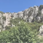
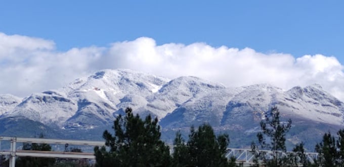
The mountains, which were formed during the third geological period along with the Taurus Mountains, are composed of folds and faults that have been eroded and uplifted during and after formation. The 175-km-long mountains are 20-30 km wide and have an average height of 1,500-2,000 meters. In the descending area in the middle of the mountain, there is Belen Pass (740 m), also known as the “Syrian Gate”. Nur Mountains are bordered by the Antakya-Kahramanmaraş graben to the east. This trench is a continuation of the fault line that passes through the Beka Valley between the Red Sea, Lut Lake, and the Lebanon-Anti-Lebanon Mountains.
The mountains extend from north to south, starting from the south of Ahır Mountain in Kahramanmaraş and ending at the Samandağ delta, where the Asi River flows into the Mediterranean Sea. Across from the point where the mountains end, there is the impressive Kel Mountain on the Syrian border. Most of the mountain range is located in Hatay and separates the Amik Plain from the Mediterranean. The highest point of the mountain range is Mığır Peak (Bozdağ) in Hassa district of Hatay, where the altitude reaches 2240 m. Other elevations of the descending mountains to the south are Kabayar Hill (1,698 m), Susuz Hill (1,072 m), Akkaya Hill (1,939 m), and Üçkaya Hill (1,976 m).
The Nur Mountains rise steeply from the Samandağ coast to the Sır Dam Lake, covering a distance of 175 km. The mountain can be roughly divided into three parts: Çimen Mountain to the north, Bozdağ in the middle, and Musa Mountain to the south. In terms of plant geography, the Nur Mountains constitute the southern part of the Anatolian Diagonal, extending from the mountains of the eastern Black Sea to the Munzur Mountains, and is one of the priority 100 forests to be protected in Europe. The mountains host Black Sea forests, Mediterranean maquis communities and
In addition to its diverse plant life, the Nur Mountains are also home to a variety of animal species, including wolves, bears, wild boars, and various bird species. The forests provide a crucial habitat for these animals, and efforts are underway to preserve the natural environment and protect endangered species.
The Nur Mountains are not only important for their natural beauty and ecological significance but also for their historical and cultural significance. The region has been inhabited for thousands of years, and there are numerous archaeological sites and historical landmarks scattered throughout the area.
One of the most notable historical sites in the region is the ancient city of Antioch, located in modern-day Antakya, near the southern end of the Nur Mountains. Antioch was founded in the 4th century BC and was once one of the largest and most prosperous cities in the Roman Empire. Today, visitors can explore the ruins of the city, including the ancient Roman bridge, the Great Mosque of Antakya, and the Hatay Archaeology Museum.
Other notable historical sites in the region include the medieval castle of Kahramanmaraş, the ruins of the ancient city of Seleucia Pieria, and the medieval church of Saint Pierre in Antakya.
For mountaineers, the Nur Mountains offer a variety of routes and terrains for climbers of different skill levels. From gentle hikes through forests and meadows to challenging climbs up steep ridges and rocky peaks, there’s something for everyone in this range. One of the most popular routes is the Mount Amanos summit trail, which takes climbers to the highest point in the range and offers stunning views of the surrounding landscape. But climbing the Nur Mountains is not just about reaching the summit. It’s also about immersing yourself in the natural and cultural beauty of the area. Along the way, climbers can visit ancient ruins and temples, explore traditional villages and markets, and sample local cuisine and wine.
The Nur Mountains are also an important cultural center, with a rich tradition of music, dance, and folk art. The region is home to numerous festivals and cultural events throughout the year, including the International Antakya Film Festival, the Kahramanmaraş International Folk Music Festival, and the Antakya International Dance Festival.
Overall, the Nur Mountains are a truly unique and special region of Turkey, offering visitors a diverse range of natural, historical, and cultural attractions. Whether you’re interested in hiking, exploring ancient ruins, or experiencing traditional Turkish culture, the Nur Mountains have something for everyone.
The Nur Mountains have a different area for everyone. You should definitely come to this region. You should come and watch the scenery, explore the mountains, and enjoy the city and its cultural texture!