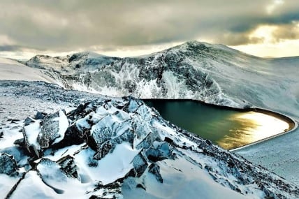
Mount Elidir Fawr
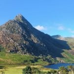
Mount Elidir Fawr is a prominent peak located in Snowdonia National Park in Wales, United Kingdom. With an elevation of 924 meters (3,031 feet), it offers stunning panoramic views of the surrounding landscapes. Situated in the northern part of Snowdonia, near the village of Bethesda, Elidir Fawr is known for its rugged beauty and challenging trails, making it a popular destination for hikers and climbers.
Where does the name Mount Elidir Fawr from? What does it mean?
The name “Elidir Fawr” has Welsh origins and holds significance in the local culture. Here’s a breakdown of its meaning:
- Elidir: Elidir is derived from the Welsh name “Elider” or “Elidyr,” which is believed to have Celtic roots. The exact etymology is uncertain, but it is thought to mean “one who returns” or “restorer.” It is a name that has been used in Welsh mythology and literature.
- Fawr: Fawr is a Welsh word that translates to “great” or “big” in English. It is commonly used in Welsh place names to indicate a large or prominent feature.
Therefore, “Elidir Fawr” can be interpreted as “The Great Elidir” or “Big Elidir.” The name emphasizes the size and prominence of the mountain within the surrounding landscape.
How to get to Mount Elidir Fawr?
To get to Dinorwig, you can use different modes of transportation. Here’s how you can reach Dinorwig using various means:
- By Plane: Since Dinorwig is a small village, there are no direct flights to the area. The nearest airport is Anglesey Airport (Ynys Mon). From Anglesey Airport, you can take a taxi or rent a car to reach Dinorwig.
- By Train: To reach Dinorwig by train, the closest train stations are Bangor and Caernarfon. From these stations, you can take a bus or a taxi to Dinorwig. There are regular train services between Bangor and Caernarfon.
- By Car: Traveling by car is the most flexible and commonly preferred option to reach Dinorwig. You can follow the main roads such as A55 or A5 to reach the village. Dinorwig is located on the A4086 road between Llanberis and Caernarfon. Using navigation or road maps, you can easily find your way to Dinorwig village.
Information on climbing Elidir Fawr Mountain
Climbing Elidir Fawr Mountain can be a rewarding experience for outdoor enthusiasts. Here’s some information to help you prepare for the climb:
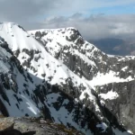
- Route: The most popular route to summit Elidir Fawr is the Llanberis Path. It starts near the village of Llanberis and offers a gradual ascent. This path is well-marked and relatively straightforward, making it suitable for beginners. Other routes, such as the Dinorwig Quarries Routes and Cwm Dudodyn Route, are also options but may require more experience and navigation skills.
- Distance and Duration: The Llanberis Path is approximately 9 kilometers (5.5 miles) long, with a total round-trip distance of about 18 kilometers (11 miles). The average time to complete the climb and return is around 5-6 hours, depending on your fitness level and pace.
What activities can be done on Elidir Fawr Mountain?
- Hiking and Mountaineering: Elidir Fawr is a popular destination for hikers and mountaineers. The ascent to the summit provides a challenging and rewarding experience. The Llanberis Path is the most commonly used route, but more experienced climbers may explore alternative routes, such as those through Dinorwig Quarries or Cwm Dudodyn.
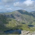
- Scenic Walks: Elidir Fawr and its surrounding area offer beautiful scenic walks for those seeking a more relaxed outing. The lower slopes of the mountain and the paths around the nearby lakes, such as Llyn Peris and Llyn Padarn, provide picturesque landscapes to explore.