Kackar Mountains Trekking
The Kaçkar Mountains are a range of mountains that stretch along the Eastern Black Sea coast in northern Turkey. Kackar Mountains Trekking forms the eastern part of the North Anatolian Mountains. Many peaks in the east are 3500 m. The western part reaches a height of 2000 m when it is above. The highest point, Kaçkar Kavrun Mountain, is 3932 m high. Kaçkar Mountains National Park was established in 1994. A large part of the national park is within the borders of Çamlıhemşin district of Rize province and a small part is within the borders of Yusufeli district of Artvin province.
It is one of the places you should see once in your life with its unique view and magnificent air. Winters are harsh and cold. For this reason, it would be better to prefer the summer months for walks. It starts in June and lasts until October.
The center and highest of the mountain range is Kaçkar Kavrun Mountains.
Kackar Mountains; It has become a center for sports such as mountaineering, rock climbing, trekking, rafting and skiing. The unique nature and cultural structure of the region attracts many local and foreign tourists. A significant part of the mountains are located within the borders of the natural park.
Those who are mountaineers can reach the summit, but people who are not mountaineers can climb to an average of 3000 meters on the condition that they fulfill some conditions and have at least 1 other person with them. It is a tiring track, you climb from 2250 meters (Upper Kavrun) to 3000 on average, the slope is too much.
You can see Kackar Nature Park on Google Map
You can see Kackar Nature Park on Google Photos
Advices:
Be sure to bring sunscreen with you. Because if there is sun, your skin can burn.
Do not go to 3000 meters directly above sea level, high altitude disturbances may occur. After staying at an average of 2000 meters (such as Yukarı Kavrun plateau), proceed.
If possible, use outdoor shoes or it can be tiring.
Download offline maps to your phone just in case.
Make sure you have a walking pole.
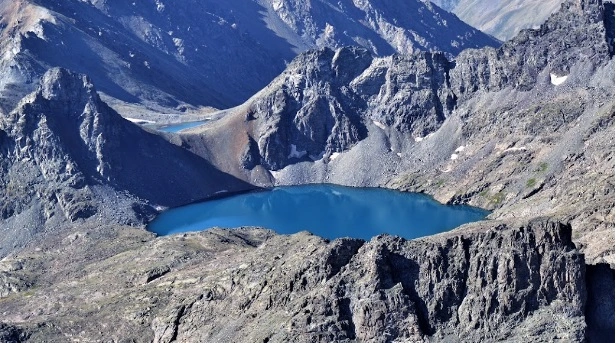
The hidden paradise in the Kaçkar Mountains Yedigöller is in the Kaçkar Mountains, at an altitude of about 4 thousand, located in the İspir district of Erzurum. Its unique beauties await you with its natural wonder peaks and crater lakes.
The Most Beautiful Routes of Kackar Mountains Trekking
1- You can reach Pokut Plateau, the best viewing terrace of Kaçar, from Çamlıhemşin.
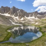
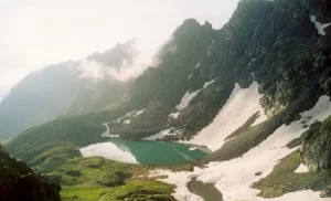
2- There are three Tatos Lakes in total, which are connected to each other and filled with the melting of the glaciers in the basin at the foot of the Tatos Mountains. You can reach Tatos Lakes from Verçenik Plateau.
3- You can take a walk to the glacial lakes by staying in the Upper Kavrun plateau. You can reach the Black Sea Lake with a 2,5-hour walk.
4- You can stay in Şenyuva Village in the Fırtına Valley and reach Zilkalesi, which is located on a hill overlooking the valley.
It is a 5-6 hour walking track that goes from Barhal (1200 m) to Özgüven Waterfall, which houses a well-preserved church built in the 5th-10th century.
6- The old Christian village of Hodacur, today’s Sırakonaklar (1700 m), houses many churches and monasteries. On the Sırakonaklar-Dalı Plateau route, you can walk on the snow on the mountain slopes in July and see the rich vegetation on the route.
7- Ayder (1200 m), as it is the most touristic settlement of the region, is the place where accommodation and food and beverage alternatives are the most. You can choose one of the accommodation options suitable for every budget in Ayder and go to the surrounding plateaus for daily walks. When you return to Ayder in the evening, you can relax in the hot spring waters.
For more information about Kackar click for the website in Extremetur.